English
Introducing the GPS Land Area Measurement App, a powerful tool that allows you to accurately measure the area and distance of any land, field, or plot using GPS and maps. Whether you are working in agriculture, real estate, or land surveying, this app is a must-have. With a variety of units available, you can easily convert and calculate measurements in feet, square feet, meters, square meters, and kilometers. Not only can you measure distance and area, but you can also find nearby places and navigate to different areas using the built-in route finder. With its highly accurate GPS mode and user-friendly interface, this app is your all-in-one solution for land measurement and navigation. Try it out and discover the endless possibilities it offers. We welcome your feedback and suggestions to continuously improve our app.
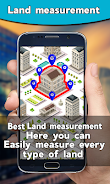
❤️ GPS Land Area Measurement: The app utilizes GPS and map technology to accurately measure the area of land, farm, and plot in various units such as feet, meters, and kilometers.
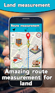
❤️ Distance Measurement: This feature allows users to measure the distance of a specific area or path by marking at least two points on the map. The app automatically calculates and displays the distance between the selected points.
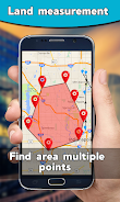
❤️ Area Measurement: By marking at least three points on the map, users can measure the area of land or field. The app automatically calculates and displays the area based on the selected points.
❤️ Unit Converter: Users have the option to convert the calculated distance and area into different units, such as feet, square feet, meters, square meters, and kilometers. This feature provides flexibility for users who work in different fields and need to convert measurements.
❤️ Nearby Places Finder: The app includes a feature that allows users to search and find nearby places, such as airports, ATMs, hospitals, restaurants, and more. This feature helps users explore their surroundings and easily find destinations.
❤️ Live Earth Map and GPS Navigation: The app provides a live earth map in different modes (normal, hybrid, satellite) and offers GPS navigation to help users navigate through land areas and find their destination.
The GPS Land Area Measurement App is a comprehensive tool for measuring land and field area. With its accurate GPS technology, users can easily calculate the distance and area of their desired location. The app also offers a unit converter, nearby places finder, and live earth map with GPS navigation, making it a versatile app for various needs. Download the app now to streamline your land measurement tasks and explore your surroundings with ease. Provide your feedback and suggestions to enhance the app's performance and features.
Camping App Van & Camping
Size:67.30M OtherAXIS Camera Station Pro & 5
Size:34.00M OtherVRTV VR Video Player Lite
Size:39.00M OtherFake
Size:48.90M OtherGetirDrive
Size:40.25M OtherChat Style - Fonts Keyboard
Size:15.45M OtherAutoCap Captions Teleprompter
Size:31.90M OtherMetronome Beats
Size:10.66M OtherQR Code & Barcode Scanner Read
Size:37.82M OtherColor Call - Call Screen App
Size:18.63M OtherCheck Thailand Lottery
Size:22.00M OtherLigaportal Fußball Live-Ticker
Size:34.50M OtherApril 2024 Clash of Clans Update: Unveiling a Fresh Companion, Enhanced Levels, Chat Tagging, and Be
2024-04-16Arrival of Genshin Impact 4.6 Update: 'Embers of Two Realms, Twilight of Crimson'
2024-04-16V2.2 of the Farlight 84 update introduces an overhauled Season structure, fresh in-game currency, an
2024-04-16Monster Never Cry is now accessible on both Android and iOS mobile devices.
2024-04-18PUBG Mobile Teams Up with Bentley Motors: Luxury Cars, Exclusive Collectibles, and Beyond
2024-04-18March 2024 Free Redemption Codes for Honkai: Star Rail
2024-04-18